 2018, Vol. 37


2. 西南大学资源环境学院, 重庆 400715;
3. 江苏省泰州学院, 江苏 泰州 225300
2. Resource and Environment Sciences, Southwest University, Chongqing 400715, China;
3. Taizhou University, Taizhou 225300, China
重金属导致土壤肥力不断退化,大幅降低农作物的产量和质量。重金属可以通过食物链在人体和其他生物体内富集,从而对人类的健康产生威胁[1−2]。土壤重金属污染的特点主要有以下3个:隐蔽性、不可逆性以及长期性。由于工业化的快速发展,导致土壤中重金属的污染越来越严重[3−6]。《土壤环境质量农用地土壤污染风险管控标准(试行)》(GB 15618— 2018)[7]对土壤中8种重金属(As、Cd、Cr、Cu、Hg、Ni、Pb和Zn)的筛选值进行了规定。为保障农业生产和维护人体健康,应加强对农用地土壤重金属的分布特点及其可能存在的生态风险进行深入了解。现阶段,土壤重金属环境质量评价的方法较多,例如地累积指数法[5]、潜在生态风险指数法[8]、富集因子法[9]、正定矩阵因子分解法[10]、单因子污染指数法和内梅罗综合污染指数法[11]等。国际上关于土壤重金属的研究最具系统性、科学性的方法是潜在生态风险指数法。潜在生态风险指数法不但考虑了重金属的含量,同时还把重金属的生态效应和生物毒性进行有效的关联,对重金属潜在的生态风险进行了定量的划分,从而对重金属进行有效的评价。该方法在土壤重金属研究中的应用非常广泛。内梅罗污染指数法可以针对不同种类的重金属元素对土壤产生的具体作用进行全面的体现。该方法最大的优势在于重点分析高浓度重金属元素对环境产生的影响作用[11]。国内学者结合我国农用地的特点在农用地分级管理及规划等方面取得了重要成果[12]。
重庆市江津区位于三峡库区库尾,是三峡库区食、蔬菜、水果及中药材的重要生产基地之一。本文以该区的农用地土壤为研究对象,分析了农用地土壤中As、Cd、Cr、Cu、Hg、Ni、Pb和Zn的污染水平。结合单因子污染指数法、内梅罗污染指数法和潜在生态风险指数法对研究区污染状况和潜在生态风险进行评价,并对研究区农用地进行安全利用分区,为即将开展的重金属土壤污染修复工作提供理论支持。
1 材料与方法 1.1 研究区域概况研究区距重庆市江津城区约15 km,是一个多土地利用格局的农业生态系统。其土地格局中,旱地所占面积最大,其次是水田,而林地的占地面积则较小。一般情况下,旱地的耕作方式主要是旱作方式,而水田则选择水旱轮流作业方式,旱作时间一般在秋末到春末期间。林地主要包括:乔木林地、竹林地及其他林地。由于该研究区受外界因素干扰较小,因此是一个较为典型的人工农业生态系统。
1.2 样品采集在研究区范围内布设网格,按照1 km×1 km打网格,网格中心作为土壤采样点,但受现场条件影响,会根据其地形地貌与土地利用类型分布特点适当调整。通过GPS对采样点的经度和纬度进行详细记录,研究区采样点位见图 1。采集0~20 cm表层土壤,每个采样点按照蛇形采样法均匀采样(6~10个样品),用四分法留下0.5~1 kg的土壤样品。将样品置于聚乙烯塑料袋中,密封保存。共采集82个土壤样品,样品采集时间为2016年5月。

|
图 1 研究区采样点位图 Figure 1 Location of sampling sites of study area |
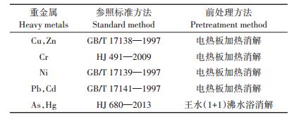
将样品均匀混合,去除石块和杂草,置于室内自然风干。研磨并过孔径为100目尼龙筛,密封保存在塑料袋中,供分析测定。参考《土壤环境质量农用地土壤污染风险管控标准(试行)》与国家标准规定的分析方法,选择合适的测试方法(表 1)。选取6~7个点(含空白)绘制标准曲线,每个样品测试3次,取其平均值作为测试试验结果。每批样品制备2个全程序空白。
|
|
表 1 检测方法及设备 Table 1 Detection method and equipment |
重金属污染既可以是单一因素作用结果,也可能是多因素共同作用的结果。为了能够定量反应研究区域土壤重金属污染情况,本文采用单因子与多因子相结合的方法对土壤污染等级与潜在生态风险等级进行评价[3]。
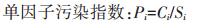
1.4.1 土壤污染评价方法目前土壤污染评价的方法较多,应用最为广泛的是单因子指数法以及内梅罗综合污染指数法[13]。土壤污染评价计算公式如下:
|

|
式中:Pi为土壤污染物i的单因子污染指数;Ci为土壤污染物i的真实测量数据;Si为土壤污染物i的具体评价标准,本文以《土壤环境质量农用地土壤污染风险管控标准(试行)》 [7]规定的筛选值作为评价标准;PN为内梅罗综合污染指数;Piave为土壤中污染物单因子污染指数的平均值;Pimax为土壤中污染物单因子污染指数的最大值。污染指数分级标准见表 2。
1.4.2 潜在生态风险评价方法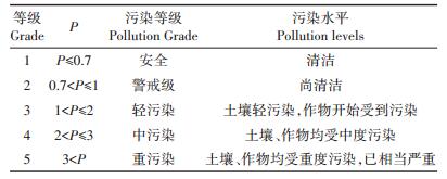
通过潜在生态危害指数法可以看出,重金属污染的潜在生态风险不仅与重金属含量有关,还与该重金属的毒性有关,因此用潜在生态风险评价方法评价更具有实际意义。单个金属潜在生态风险等级(Eri)表示单一因素生态风险,综合潜在生态风险等级(RI)表示多因素共同作用生态风险。
潜在生态风险评价计算公式如下:
|

|

|
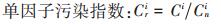
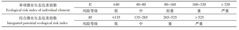
式中:Cri为金属i的污染指数;Ci为金属i的实测含量;Cni为金属i的评价参比值,本文选用三峡库区土壤重金属背景值[14];Eri为单个金属i的潜在生态风险指数;Tri为金属i的毒性响应系数,As、Cd、Cr、Cu、Hg、Ni、Pb、Zn的Tri分别为10、30、2、5、40、5、5、1[5];RI为综合潜在生态风险指数。潜在生态风险分级标准如表 3所示。
|
|
表 3 Eri和RI分级标准 Table 3 Grade standard of Eri and RI |
基于单因子指数法、内梅罗综合污染指数法和潜在生态风险指数法评价结果,参照中国地质大学刘霈珈[15]提出的农用地安全利用划分方案将研究区农用地进行安全利用分级。
1.5 数据处理数据处理采用SPSS 22.0和Excel 2003软件,采样点分布图与克里格插值分析采用ArcGIS 10.2.2软件完成。
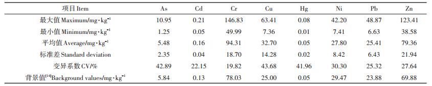
2 结果与讨论 2.1 研究区农用地土壤重金属污染分布特征研究区农用地土壤重金属测试结果见表 4。从表 4可以看出,样品中除As、Hg、Ni外,Cd、Cr、Cu、Pb、Zn的平均含量均高于三峡库区农业土壤背景值[14]。超标倍数为1.43~2.54倍,表明该研究区土壤中重金属Cd、Cr、Cu、Pb、Zn存在不同程度的累积。其中12.20%的土壤样品Cu含量超过《土壤环境质量农用地土壤污染风险管控标准(试行)》的筛选值。有研究表明,Cd、Cr、Cu、Pb与汽车尾气排放有关,是机动车污染源的标记元素,Cr主要受土壤母质和成土过程影响[16]。通过变异系数可以有效地反映出总体样本中各个不同采样点的平均变异程度。如果变异系数超过0.5,则说明土壤中重金属含量存在空间分布不均匀现象,由于外源物质的进入,导致在某一局部地区出现点源污染。研究区农用地土壤样品中As、Cu和Hg变异系数较大,接近0.5,表明可能存在外源物质进入引起的点源污染。土壤As与有机肥、城市有机废物、城市污泥有关[17]。另有研究表明Cr、Cu、Zn、Cd主要受化肥、农药、有机肥、污水灌溉等农业活动的影响。对As与Hg产生影响作用的因素主要有燃煤、废弃物的排放以及工业废水等[10]。江津区内有德感、白沙、双福三个工业园区,研究区距离城区较近。推测研究区多种重金属高于背景值的原因可能是受城市效应、工业基地、农业活动共同因素的影响。
|
|
表 4 土壤重金属含量统计分析 Table 4 Statistic values of heavy metal concentration of soil |
为了对研究区农用地土壤重金属含量空间分布特征进行深入了解,通过ArcGIS 10.2.2软件用克里格插值技术得到土壤重金属含量空间分布图(图 2)。从图 2可以看出,Cu、Ni和Zn空间分布规律特征基本相同,As和Cr空间分布规律特征基本相同。Cd和Hg空间分布相对较均匀,且低值区出现位置相似,提示元素间具有一定相关关系。有研究表明,不同重金属间一般具有同源关系或存在复合污染的现象[16]。Pb空间分布规律特性区别于其他重金属,提示Pb与其他重金属相关性较差,表明Pb可能存在单独的污染来源。研究区土壤中重金属分布差异性较大的原因有以下两个:其一,不同区域土壤的背景值可能存在不同;其二,受人类不同活动的影响[10]。

|
图 2 研究区土壤重金属含量空间分布 Figure 2 Spatial distribution of heavy metal concentrations in study area |
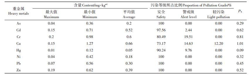
为了进一步评价研究区域土壤重金属的污染程度,并对土壤中重要的污染物进行有效识别,以《土壤环境质量农用地土壤污染风险管控标准(试行)》 [7]规定的筛选值作为土壤重金属污染程度评价的标准,利用单因子污染指数法和综合污染指数法分析了研究区重金属污染等级,分析结果见表 5。从表 5中可以看出,有2.44%土壤样品Cd、19.51%土壤样品Cr、14.63%土壤样品Cu、9.76%土壤样品Hg为警戒级,12.20%采样点的Cu为轻污染级。但是研究区8种重金属单项污染指数(Pi)平均值均小于0.7,污染等级均为安全级。内梅罗综合污染指值数(PN)顺序为Cu(1.01)>Cr(0.81)>Cd(0.62)>Zn(0.52)>Pb(0.45)>Ni(0.32)>As(0.29)>Hg(0.09)。内梅罗综合污染指数结果表明:Cu污染等级为轻污染,Cr污染等级为警戒级,其余6种重金属为安全级。内梅罗综合污染指数法属于一种计权型单因子环境质量评价方法,其最大特点在于突出单因子污染指数的最大值。所以,通过内梅罗污染指数评价结果可以看出,研究区农用地土壤受到Cu的轻度污染。
|
|
表 5 研究区土壤污染评价 Table 5 Pollution assessment of soil for heavy metals in study area |
以2008年唐将等[14]提出的三峡库区土壤背景值为参比值,得出各采样点单项潜在生态危害指数和综合潜在生态危害指数,统计分析结果见图 3。从图 3可以看出,研究区农用地土壤重金属的单项潜在生态危害指数平均值从大到小依次为Hg(41.33)>Cd(36.71)>As(12.20)>Cu(6.54)>Pb(5.32)>Ni(4.72)> Cr(2.42)>Zn(1.14)。Hg的Eri均值大于40,处于中等生态风险等级,其余7种重金属Eri均值小于40,As、Cd、Cr、Cu、Ni、Pb和Zn整体上表现为低生态风险等级。Cd和Hg处于中等生态风险等级样品所占比例分别为4.25%和67.5%。虽然Cd的平均浓度只有0.16 mg·kg-1,比背景值高出一点,但是Cd重金属的毒性系数等于30,其单项潜在生态危害指数为36.71。Hg的平均浓度只有0.05 mg·kg-1,与背景值相同,但是Hg的毒性系数等于40,其单项潜在生态危害指数为41.33。从以上数据可以看出,研究区农用地土壤中Hg与Cd单项潜在生态危害指数之所以比较高的原因是Hg和Cd的高毒性系数,而非Hg和Cd的高含量[17]。研究区综合潜在生态危害指数RI范围为68.57~143.57,平均值为110.37,仅有9.76%的土壤样品RI值大于135。从评价结果可以明显看出,目前研究区农用地土壤重金属综合潜在生态风险等级属于低风险等级,研究区农用地土壤重金属潜在生态危害主要来自Hg和Cd。有研究表明,重庆不同功能区绿地土壤Hg含量高于重庆市背景值,且与土壤有机质呈现正相关,表明人类活动是影响Hg富集的主要因素[18]。

|
图 3 研究区土壤重金属单项生态危害指数评价结果 Figure 3 Ecological risk index of individual element for heavy metals in study area |
针对农用地合理利用和管理,刘霈珈等[15]提出农用地安全利用划分方案,将农用地划分为5种综合分区,即Ⅰ级(安全利用区)、Ⅱ级(基本安全利用区)、Ⅲ级(低风险监控区)、Ⅳ级(中风险预警区)和Ⅴ级(高风险限制区)。基于单因子指数法、内梅罗综合污染指数法和潜在生态风险指数法评价结果,利用上述分级方案对研究区农用地进行安全利用分级,图 4为研究区农用地安全利用综合分区图。Ⅰ级安全利用区面积为68.39 km2,占农用地总面积的79.53%,Ⅱ级基本安全利用区面积为13.73 km2,占农用地总面积的15.97%,Ⅲ级低风险监控区面积为3.88 km2,占农用地总面积的4.50%。研究区农用地均为Ⅰ、Ⅱ和Ⅲ级利用区,无Ⅳ级和Ⅴ级利用区。表明研究区农用地安全利用等级较低,该分区结果及其空间分布特征为后续农用地安全利用和管理提供重要依据。

|
图 4 农用地安全利用综合分区 Figure 4 Comprehensive zones of agricultural land safe utilization |
(1)研究区农用地表层土壤中,除As(5.48 mg·kg-1)、Hg(0.05 mg·kg-1)和Ni(27.80 mg·kg-1)的平均值未超过三峡库区农业土壤重金属背景值以外,Cr(94.31 mg·kg-1)、Zn(79.36 mg·kg-1)、Cu(32.70 mg· kg-1)、Pb(25.41 mg·kg-1)、Cd(0.16 mg·kg-1)的平均值均高于背景值。其中有12.20%的土壤样品Cu含量超过《土壤环境质量农用地土壤污染风险管控标准(试行)》筛选值。
(2)内梅罗综合污染指数结果表明研究区农用地表层土壤中Cu污染等级为轻污染,Cr污染等级为警戒级,其余6种重金属为安全级。单项潜在生态风险指数顺序为Hg(41.33)>Cd(36.71)>As(12.20)>Cu(6.54)>Pb(5.32)>Ni(4.72)>Cr(2.42)>Zn(1.14),Hg为中等生态风险,其他7种重金属为较低生态风险,Hg和Cd是影响研究区农用地土壤重金属综合潜在生态风险的主要元素,整个研究区农用地土壤综合潜在生态风险危害为低风险水平。
(3)研究区农用地土壤79.53%的面积属于安全利用区,15.97%的面积属于基本安全利用区,4.50%的面积属于低风险监控区,且不涉及中风险预警区和高风险限制区。
| [1] |
邱孟龙, 李芳柏, 王琦, 等. 工业发达城市区域耕地土壤重金属时空变异与来源变化[J]. 农业工程学报, 2015, 31(2): 298-305. QIU Meng-long, LI Fang-bai, WANG Qi, et al. Spatio-temporal variation and source changes of heavy metals in cultivated soils in industrial developed urban areas[J]. Transactions of the Chinese Society of Agricultural Engineering, 2015, 31(2): 298-305. DOI:10.3969/j.issn.1002-6819.2015.02.041 |
| [2] |
Hu Y N, Liu X P, Bai J M, et al. Assessing heavy metal pollution in the surface soils of a region that had undergone three decades of intense industrialization and urbanization[J]. Environmental Science and Pollution Research, 2013, 20(9): 6150-6159. DOI:10.1007/s11356-013-1668-z |
| [3] |
索琳娜, 刘宝存, 赵同科, 等. 北京市菜地土壤重金属现状分析与评价[J]. 农业工程学报, 2016, 32(9): 179-186. SUO Lin-na, LIU Bao -cun, ZHAO Tong-ke, et al. Evaluation and analysis of heavy metals in vegetable field of Beijing[J]. Transactions of the Chinese Society of Agricultural Engineering, 2016, 32(9): 179-186. |
| [4] |
Lu A X, Wang J H, Qin X Y, et al. Multivariate and geostatistical analyses of the spatial distribution and origin of heavy metals in the agricultural soils in Shunyi, Beijing, China[J]. Science of The Total Environment, 2012, 425: 66-74. DOI:10.1016/j.scitotenv.2012.03.003 |
| [5] |
刘成, 邵世光, 范成新, 等. 巢湖重污染汇流湾区沉积物重金属污染特征及风险评价[J]. 中国环境科学, 2014, 34(4): 1031-1037. LIU Cheng, SHAO Shi-guang, FAN Cheng-xin, et al. Pollution status and risk assessment of heavy metal in the sediment of the severe polluted confluence area of Lake Chaohu[J]. China Environmental Science, 2014, 34(4): 1031-1037. |
| [6] |
马啸, 左锐, 王金生, 等. 沈阳浑河冲洪积扇土壤的重金属空间分布特征及来源[J]. 环境科学研究, 2014, 27(11): 1298-1305. MA Xiao, ZUO Rui, WANG Jin-sheng, et al. Spatial distribution and sources of heavy metals in soils from alluvial and diluvial fan of Hun River in Shenyang[J]. Research of Environmental Sciences, 2014, 27(11): 1298-1305. |
| [7] |
生态环境部, 国家市场监督管理总局.土壤环境质量农用地土壤污染风险管控标准(试行): GB 15618-2018[S].北京: 中国标准出版社, 2018. Ministry of Ecology and Environment, State Administration of Markets. Soil environmental quality risk control standard for soil contaminaton of agricultural land(Trial): GB 15618-2018[S]. Beijing: China Standard Press, 2018. |
| [8] |
雷国建, 陈志良, 刘千钧, 等. 广州郊区土壤重金属污染程度及潜在生态危害评价[J]. 中国环境科学, 2013, 33(增刊1): 49-53. LEI Guo-jian, CHEN Zhi-liang, LIU Qian-jun, et al. The assessments of polluted degree and potential ecological hazards of heavy metals in suburban soil of Guangzhou City[J]. China Environmental Science, 2013, 33(Suppl1): 49-53. |
| [9] |
肖雪, 赵南京, 袁静, 等. 淮河流域某镇农业土壤重金属含量特征及污染评价[J]. 光谱学与光谱析, 2014, 34(7): 1785-1788. XIAO Xue, ZHAO Nan-jing, YUAN Jing, et al. Analysis of heavy metals distribution characteristics and pollution assessment in agricultural region soils of Huaihe basin[J]. Spectroscopy and Spectral Analysis, 2014, 34(7): 1785-1788. |
| [10] |
李娇, 陈海洋, 滕彦国, 等. 拉林河流域土壤重金属污染特征及来源解析[J]. 农业工程学报, 2016, 32(19): 226-233. LI Jiao, CHEN Hai-yang, TENG Yan-guo, et al. Contamination characteristics and source apportionment of soil heavy metals in Lalin River basin[J]. Transactions of the Chinese Society of Agricultural Engineering, 2016, 32(19): 226-233. DOI:10.11975/j.issn.1002-6819.2016.19.031 |
| [11] |
郭伟, 孙文惠, 赵仁鑫, 等. 呼和浩特市不同功能区土壤重金属污染特征及评价[J]. 环境科学, 2013, 34(4): 1561-1567. GUO Wei, SUN Wen-hui, ZHAO Ren-xin, et al. Characteristic and evaluation of soil pollution by heavy metal in different functional zones of Hohhot[J]. Environmental Science, 2013, 34(4): 1561-1567. |
| [12] |
刘霈珈, 吴克宁, 赵华甫. 基于农用地分等与土地质量地球化学评估的耕地质量监测类型研究[J]. 资源科学, 2015, 37(1): 37-44. LIU Pei -jia, WU Ke-ning, ZHAO Hua-fu. Cultivated land quality monitoring types base on agricultural land classification and land quality geochemical assessment[J]. Resources Science, 2015, 37(1): 37-44. |
| [13] |
李良忠, 杨彦, 蔡慧敏, 等. 太湖流域某农业活动区农田土壤重金属污染的风险评价[J]. 中国环境科学, 2013, 33(增刊1): 60-65. LI Liang-zhong, YANG Yan, CAI Hui-min, et al. Pollution status and risk assessment of heavy metal in the sediment of the severe polluted confluence area of Lake Taihu[J]. China Environmental Science, 2013, 33(Suppl1): 60-65. |
| [14] |
唐将, 钟远平, 王力. 三峡库区土壤重金属背景值研究[J]. 中国生态农业学报, 2008, 16(4): 848-852. TANG Jiang, ZHONG Yuan-ping, WANG Li. Background value of soil heavy metal in the Three Gorges Reservoir District[J]. Chinese Journal of Eco-Agriculture, 2008, 16(4): 848-852. |
| [15] |
刘霈珈, 吴克宁, 罗明, 等. 农用地土壤重金属超标评价与安全利用分区[J]. 农业工程学报, 2016, 32(23): 254-262. LIU Pei-jia, WU Ke-ning, LUO Ming, et al. Evaluation of agricultural land soil heavy metal elements exceed standards and safe utilization zones[J]. Transactions of the Chinese Society of Agricultural Engineering, 2016, 32(23): 254-262. DOI:10.11975/j.issn.1002-6819.2016.23.035 |
| [16] |
湛天丽, 黄阳, 滕应, 等. 贵州万山汞矿区某农田土壤重金属污染特征及来源解析[J]. 土壤通报, 2017, 48(2): 474-480. ZHAN Tian-li, HUANG Yang, TENG Ying, et al. Pollution characteristics and sources of heavy metals in farmland soil in Wanshan mining areas, Guizhou Province[J]. Chinese Journal of Soil Science, 2017, 48(2): 474-480. |
| [17] |
鲁长娟, 张菊, 董杰, 等. 聊城市城区水岸带土壤Hg, As含量分布特征及污染评价[J]. 河南师范大学学报(自然科学版), 2017, 45(2): 43-47. LU Chang-juan, ZHANG Ju, DONG Jie, et al. Distribution character and pollution assessment of mercury and arsenic concentrations in riparian soils of Liaocheng urban area[J]. Journal of Henan Normal University (Natural Science Edition), 2017, 45(2): 43-47. |
| [18] |
徐福银, 胡艳燕, 包兵, 等. 重庆市不同功能区绿地土壤Hg分布特征及其污染评价[J]. 土壤通报, 2015, 46(5): 1253-1258. XU Fu-yin, HU Yan-yan, BAO Bing, et al. Distribution characters and pollution evaluation of Hg in urban soils of different functional area in Chongqing[J]. Chinese Journal of Soil Science, 2015, 46(5): 1253-1258. |